


Tbd Fm 900
Mount Vernon, TX 75457
- – beds
- – baths
- – sqft
- ~6 acre lot
- – on site
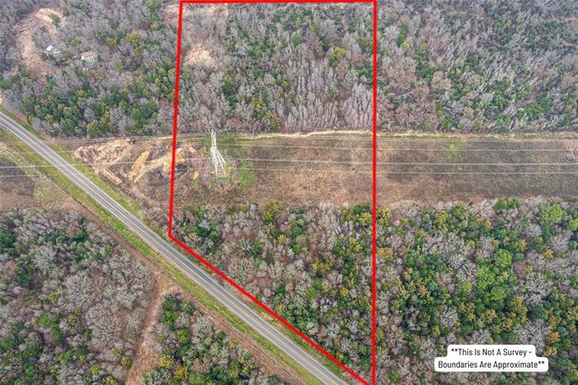
Neat, mostly wooded 5.72-acre rectangular tract a coup0le of miles west of Purley on FM 900 about 8 minutes out of Mt. Vernon. The property is over 325' wide and has about 400' of road frontage. It averages about 765' deep. Approximately 40% of the property is cleared and includes a powerline right-of-way. This right-of-way through the south half of the property provides an open area for a horse or two. The balance of the property is heavily wooded. All utilities are available at the road.
![]()
Last checked:
As a licensed real estate brokerage, Estately has access to the same database professional Realtors use: the Multiple Listing Service (or MLS). That means we can display all the properties listed by other member brokerages of the local Association of Realtors—unless the seller has requested that the listing not be published or marketed online.
The MLS is widely considered to be the most authoritative, up-to-date, accurate, and complete source of real estate for-sale in the USA.
Estately updates this data as quickly as possible and shares as much information with our users as allowed by local rules. Estately can also email you updates when new homes come on the market that match your search, change price, or go under contract.
![]() Checking…
•
Last updated Apr 2, 2025
•
Checking…
•
Last updated Apr 2, 2025
•
MLS# 20841844 —
Location
-
Directions:From Purley on Hwy 37, W on FM 900 approximately 2 miles to Property on the N side of the road, just past CR 3010 and before you get to CR 3170. Property is on N side of FM 900,just E of CR 3170 Front corners are marked with red survey tape. Sign on the Property.
-
Latitude:33.09866138
-
Longitude:-95.28770787
The Property
-
Property Type:Land
-
Property Subtype:Unimproved Land
-
Parcel Number:21579
-
Lot Features:Acreage, Many Trees, Oak, Pasture
-
Lot Size:5 to < 10 Acres
-
Lot Size Dimensions:325x765
-
Lot Size SqFt:249163.2000
-
Lot Size Acres:5.7200
-
Lot Size Area:5.7200
-
Lot Size Units:Acres
-
Lot Size Source:See Remarks
-
Easements:Electric
-
Restrictions:No Restrictions
-
Current Use:Vacant
-
Possible Use:Agricultural, Barndominium, Equine
-
Zoning Description:Unzoned
-
Topography:level
-
Fencing:None
-
Crops:Native
-
Soil Type:Sandy Loam
-
Vegetation:Heavily Wooded
-
Acres Pasture:2.00
-
Frontage Feet:401
-
Waterfront:No
-
Lake Pump:No
-
Surface Rights:All
-
Road Frontage Type:FM Road
-
Road Surface Type:Asphalt
-
Will Subdivide:No
Listing Agent
- Contact info:
- No listing contact info available
The Listing
-
Virtual Tour URL Unbranded:https://www.propertypanorama.com/instaview/ntreis/20841844
Utilities
-
Utilities:All Weather Road, Asphalt, Cable Available, Co-op Electric, Co-op Water, Electricity Available, Outside City Limits, Overhead Utilities, Phone Available, Rural Water District
Schools
-
School District:Mount Vernon ISD
-
Elementary School:Mt Vernon
-
Elementary School Name:Mt Vernon
-
Middle School Name:Mt Vernon
-
High School Name:Mt Vernon
The Community
-
Subdivision Name:N.A.
-
Association Type:None
-
Development Status:Unzoned
Walk Score®
Provided by WalkScore® Inc.
Walk Score is the most well-known measure of walkability for any address. It is based on the distance to a variety of nearby services and pedestrian friendliness. Walk Scores range from 0 (Car-Dependent) to 100 (Walker’s Paradise).
Bike Score®
Provided by WalkScore® Inc.
Bike Score evaluates a location's bikeability. It is calculated by measuring bike infrastructure, hills, destinations and road connectivity, and the number of bike commuters. Bike Scores range from 0 (Somewhat Bikeable) to 100 (Biker’s Paradise).