


Stanley Rd
Stanley, NM 87056
- – beds
- – baths
- – sqft
- ~78 acre lot
- – on site
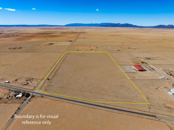
Two contiguous parcels, located in the center of Stanley, NM, totaling 77.67 acres. The westernmost parcel, situated at the corner of NM-472 and NM-41, spans 37.67 acres, while the adjoining eastern parcel covers 40 acres. Each parcel features two private wells. The property is zoned RES-E (Residential Estate) with an O-RC (Rural Commercial Overlay District), offering flexibility for residential and limited commercial use. Potential uses include single-family homes and townhomes on medium-sized lots, consistent with contemporary community development. Agricultural uses may include crop production, grazing, and ranching. Additional permitted uses include daycare centers, group homes, medical clinics, and retirement housing. All projects will require zoning verification.
![]()
Last checked:
As a licensed real estate brokerage, Estately has access to the same database professional Realtors use: the Multiple Listing Service (or MLS). That means we can display all the properties listed by other member brokerages of the local Association of Realtors—unless the seller has requested that the listing not be published or marketed online.
The MLS is widely considered to be the most authoritative, up-to-date, accurate, and complete source of real estate for-sale in the USA.
Estately updates this data as quickly as possible and shares as much information with our users as allowed by local rules. Estately can also email you updates when new homes come on the market that match your search, change price, or go under contract.
![]() Checking…
•
Last updated Apr 8, 2025
•
Checking…
•
Last updated Apr 8, 2025
•
MLS# 1081561 —
Location
-
Directions:From I-40, take the second Moriarty exit and head North on NM-41. Continue approx. 5.5 miles to 472, go left and the property will be immediately on the right.
-
Latitude:35.143283
-
Longitude:-105.981073
The Property
-
Parcel Number:960001094
-
Property Type:Land
-
Zoning Description:RES-E
-
Current Use:Unimproved
-
Possible Use:Unimproved
-
Topography:Level
-
Lot Features:Meadow,SplitPossible,Views,Acreage
-
Lot Size Acres:77.67
-
Lot Dimensions Source:Other
-
Lot Size SqFt:3383305.0
-
Lot Size Source:Estimated
-
# of Lots:2
-
View:true
Listing Agent
- Contact info:
- Agent phone:
- (505) 280-7777
- Office phone:
- (505) 554-2213
Taxes
-
Tax Lot:N/A
-
Tax Block:N/A
-
Tax Tract:N/A
-
Tax Annual Amount:2213.0
Utilities
-
Utilities:ElectricityAvailable,SewerNotAvailable
-
Sewer:None
-
Water Source:Private,Well
The Community
-
Subdivision Name:N/A
Walk Score®
Provided by WalkScore® Inc.
Walk Score is the most well-known measure of walkability for any address. It is based on the distance to a variety of nearby services and pedestrian friendliness. Walk Scores range from 0 (Car-Dependent) to 100 (Walker’s Paradise).
Bike Score®
Provided by WalkScore® Inc.
Bike Score evaluates a location's bikeability. It is calculated by measuring bike infrastructure, hills, destinations and road connectivity, and the number of bike commuters. Bike Scores range from 0 (Somewhat Bikeable) to 100 (Biker’s Paradise).
Sale history
| Date | Event | Source | Price | % Change |
|---|---|---|---|---|
|
4/8/25
Apr 8, 2025
|
Listed / Active | SWMLS | $230,000 |