


No Strret Name
OAK HILL, FL 32759
- – beds
- – baths
- – sqft
- ~3 acre lot
- – on site
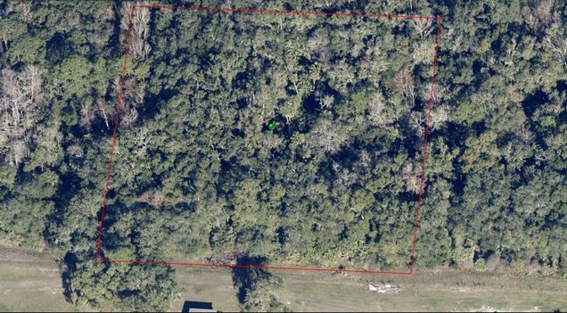
BEAUTIFUL 2,5 ACRES ALL HIGH AND DRY, CAPE ATLANTIC & AIRSTRIP AREA, BUYER TO VERIFY PERMMITED USES WITH THE COUNTY, ALL INSPECTION AND DUE DILIGENCE MUST BE COMPLETED PRIOR TO SEND A CONTRACT. THIS PROPERTY WAS ACQUIRED VIA TAX DEED(FORECLOSURE), SOLD AS IS.
![]()
Last checked:
As a licensed real estate brokerage, Estately has access to the same database professional Realtors use: the Multiple Listing Service (or MLS). That means we can display all the properties listed by other member brokerages of the local Association of Realtors—unless the seller has requested that the listing not be published or marketed online.
The MLS is widely considered to be the most authoritative, up-to-date, accurate, and complete source of real estate for-sale in the USA.
Estately updates this data as quickly as possible and shares as much information with our users as allowed by local rules. Estately can also email you updates when new homes come on the market that match your search, change price, or go under contract.
![]() Checking…
•
Last updated Apr 10, 2025
•
Checking…
•
Last updated Apr 10, 2025
•
MLS# G5094847 —
The Building
-
Building Area Units:Square Feet
Room Dimensions
-
Living Area Units:Square Feet
Location
-
Directions:MAYTOWN RD. TO BIRITZ-STRATTON THEN FOLLOW THE COORDINATES TO THE SITE, 28.85514,-80.90629
-
Latitude:28.85514
-
Longitude:-80.90629
-
Coordinates:-80.90629, 28.85514
The Property
-
Parcel Number:844702071350
-
Property Type:Land
-
Lot Size Acres:2.5
-
Lot Size Area:2.5
-
Lot Size SqFt:108900
-
Lot Size Dimensions:312' x 349'
-
Lot Size Units:Acres
-
Total Acres:2 to less than 5
-
Zoning:A-1
-
Current Use:Agricultural
-
View:false
-
Water Source:None
-
Road Surface Type:Unimproved
-
Flood Zone Code:X
-
Flood Zone Panel:12127C0825J
-
Additional Parcels:false
-
Price Per Acre:13600
Listing Agent
- Contact info:
- Agent phone:
- (407) 312-6424
- Office phone:
- (407) 312-6424
Taxes
-
Tax Year:2024
-
Tax Lot:135
-
Tax Block:07
-
Tax Legal Description:47-18-34 E 330 FT OF W 11220 FT OF S 330 FT OF N 12540 FT OF JN LOWE GRANT AKA LOT 135 CAPE ATL SEC G UNREC SUB NO 222 PER OR 1712 PG 612 EXC 50% SUBSURFACE RIGHTS PER OR 8438 PG 1218
-
Tax Book Number:2127-1823
-
Tax Annual Amount:33
The Listing
-
Special Listing Conditions:None
Utilities
-
Utilities:Other
-
Sewer:None
The Community
-
Subdivision Name:CAPE ATLANTIC ESTATES SEC A 01 UNREC 237
-
Waterview:false
-
Water Access:false
-
Waterfront:false
-
Association:false
-
Ownership:Fee Simple
Walk Score®
Provided by WalkScore® Inc.
Walk Score is the most well-known measure of walkability for any address. It is based on the distance to a variety of nearby services and pedestrian friendliness. Walk Scores range from 0 (Car-Dependent) to 100 (Walker’s Paradise).
Bike Score®
Provided by WalkScore® Inc.
Bike Score evaluates a location's bikeability. It is calculated by measuring bike infrastructure, hills, destinations and road connectivity, and the number of bike commuters. Bike Scores range from 0 (Somewhat Bikeable) to 100 (Biker’s Paradise).
Sale history
| Date | Event | Source | Price | % Change |
|---|---|---|---|---|
|
4/10/25
Apr 10, 2025
|
Price Changed | STELLAR_MLS | $34,000 | -2.9% |
|
3/29/25
Mar 29, 2025
|
Listed / Active | STELLAR_MLS | $35,000 |