Lacock Kelchner Rd
Underwood, WA 98651
- – beds
- – baths
- – sqft
- ~32 acre lot
- – on site
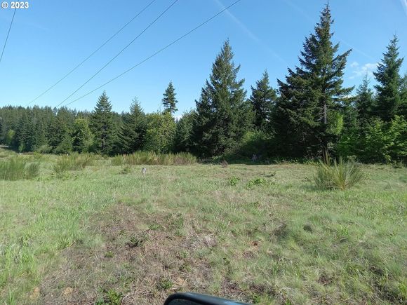
HUGE opportunity knocking for someone looking for a homesite close to town, privacy, dividable, potential for development, water, power and phone available at property line, will need septic. Borders the National Scenic Area boundary but not inside the NSA, so no negative impact for development here. This is a large parcel with a top of Mt. Adams view. Lower Underwood location, easily accessible, growing marketable timber, good zoning, lots of potential. 31+ acres of your own ground. Build your very private dream home just a few minutes from everything, work or play. Good area for vineyards. Easy access to all existing recreational and social venues here in the central gorge. Hunting, fishing, all the summer water sports, close to all the winter sports and hiking year-round. This IS the gorge!

Last checked:
As a licensed real estate brokerage, Estately has access to the same database professional Realtors use: the Multiple Listing Service (or MLS). That means we can display all the properties listed by other member brokerages of the local Association of Realtors—unless the seller has requested that the listing not be published or marketed online.
The MLS is widely considered to be the most authoritative, up-to-date, accurate, and complete source of real estate for-sale in the USA.
Estately updates this data as quickly as possible and shares as much information with our users as allowed by local rules. Estately can also email you updates when new homes come on the market that match your search, change price, or go under contract.
Checking…
•
Last updated Jan 11, 2025
•
MLS# 23105098 —
Financial & Terms
-
Bank Owned:false
-
Land Lease:false
-
Short Sale:false
Location
-
Directions:Hwy 14 to Cook Underwood Rd, to Lacock-Kelchner RD (follow Howard wrecking yard signs); RE signs
-
Latitude:45.755068
-
Longitude:-121.550532
The Property
-
Parcel Number:03100900040000
-
Property Type:Land
-
Property Subtype:Farm
-
Land Description:GentleSloping
-
# of Lots:1
-
Lot Features:MerchantableTimber, Private, PrivateRoad, PublicRoad, Secluded, Wooded
-
Lot Size Range:Acres20to50
-
Lot Size Acres:31.6
-
Lot Size SqFt:1376496.0
-
Lot Size Dimensions:1115 x 1320 m/l
-
Zoning:R10
-
Current Use:RawLand,Timber
-
View:true
-
View Description:Mountain, Territorial, TreesWoods
-
Waterfront:false
-
Soil Condition:Native
-
Soil Type Classification:native
-
Existing Structures:false
-
Property Attached:false
-
Additional Parcels:false
-
Road Frontage:true
-
Road Surface Type:Gravel,Paved
Listing Agent
- Contact info:
- Agent phone:
- (509) 637-3997
- Office phone:
- (360) 727-1077
Taxes
-
Tax Year:2022
-
Tax Legal Description:Exhibit A Legal to be attached. NOT OF CONT BK 203PG 859 BK FPG 10 MANAGEMENT PLAN REC 1162001
-
Tax Annual Amount:53.42
Heating & Cooling
-
Heating:false
-
Cooling:false
Utilities
-
Utilities:ElectricityAvailable,PhoneAvailable,WaterAvailable
Schools
-
Elementary School:Mill A
-
Elementary School:Whitson
-
Middle Or Junior School:Henkle
-
High School:Columbia
-
High School:Other
Parking
-
Attached Garage:false
Walk Score®
Provided by WalkScore® Inc.
Walk Score is the most well-known measure of walkability for any address. It is based on the distance to a variety of nearby services and pedestrian friendliness. Walk Scores range from 0 (Car-Dependent) to 100 (Walker’s Paradise).
Sale history
| Date | Event | Source | Price | % Change |
|---|---|---|---|---|
|
3/20/24
Mar 20, 2024
|
Price Changed | RMLS | $1,250,000 | -16.7% |
|
7/10/23
Jul 10, 2023
|
Listed / Active | RMLS | $1,500,000 |


