


Highway 69 Lot 12
Gardner, CO 81040
- – beds
- – baths
- – sqft
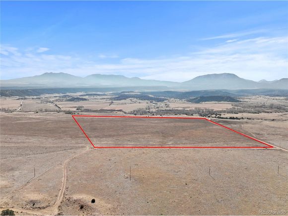
- ~44 acre lot
- – on site
Welcome To The Perfect Site To Build Your Mountain Retreat * This 44.08 Acre Parcel Sits Just Off State Highway 69 & is surrounded by incredible mountain views in all directions * The level lot is fenced on two sides * Quick Access to Public Lands with Two BLM Parcels with over 3,000 Acres Located Just 2 Miles Away & Another BLM Parcel with 7,000+ Acres Connecting to the San Isabel National Forest Less Than a Mile Away * Turkey Creek is Located 1/4 Mile To The East & the Huerfano River is Just Across The Street Located on the South Side of Highway 69 * Currently Zoned Agricultural w/ No HOA * Adjoining 44 Acre Parcel Can Be Purchased Combined or Separately
![]()
Last checked:
As a licensed real estate brokerage, Estately has access to the same database professional Realtors use: the Multiple Listing Service (or MLS). That means we can display all the properties listed by other member brokerages of the local Association of Realtors—unless the seller has requested that the listing not be published or marketed online.
The MLS is widely considered to be the most authoritative, up-to-date, accurate, and complete source of real estate for-sale in the USA.
Estately updates this data as quickly as possible and shares as much information with our users as allowed by local rules. Estately can also email you updates when new homes come on the market that match your search, change price, or go under contract.
![]() Checking…
•
Last updated Mar 27, 2025
•
Checking…
•
Last updated Mar 27, 2025
•
MLS# 7082005 —
This property is listed in more than one place. See it here.
The Building
-
New Construction:false
Room Dimensions
-
Living Area Units:Square Feet
Financial & Terms
-
Listing Terms:Cash
Location
-
Directions:Use 20014 CO-69, Gardner, CO 81040 in GPS to get to southwest corner of property. From I-25, take Exit 56 (Red Rock Road) west 2.5 miles to SH 69, turn right (north/northwest) onto SH69 for 14.6 miles, turn right (north) onto private road for 0.2 miles, turn right into gated entry with lockbox. Property will be on your right (south). Property is between Mile Marker 19 & 20.
-
Coordinates:-105.080811, 37.75256
-
Latitude:37.75256
-
Longitude:-105.080811
The Property
-
Property Type:Land
-
Property Subtype:Unimproved Land
-
Lot Features:Level
-
Lot Size Acres:44.08
-
Lot Size SqFt:1920125
-
Lot Size Area:1920125
-
Lot Size Units:Square Feet
-
Zoning:A
-
View:Mountain(s)
-
Current Use:Horses
-
Exclusions:None
-
Horse:true
-
Fencing:Partial
-
Water Source:No Water/Sewer
-
Waterfront:false
Listing Agent
- Contact info:
- No listing contact info available
Taxes
-
Tax Year:2023
-
Tax Annual Amount:1074.4
The Listing
-
Special Listing Conditions:Private Owner
Utilities
-
Electric:Electricity at Property
-
Sewer:No Water/Sewer
Schools
-
High School District:Huerfano RE-1
The Community
-
Subdivision Name:Southwinds Ranch
-
Association:false
-
Senior Community:false
Parking
-
Attached Garage:false
-
Garage Type:None
Walk Score®
Provided by WalkScore® Inc.
Walk Score is the most well-known measure of walkability for any address. It is based on the distance to a variety of nearby services and pedestrian friendliness. Walk Scores range from 0 (Car-Dependent) to 100 (Walker’s Paradise).
Bike Score®
Provided by WalkScore® Inc.
Bike Score evaluates a location's bikeability. It is calculated by measuring bike infrastructure, hills, destinations and road connectivity, and the number of bike commuters. Bike Scores range from 0 (Somewhat Bikeable) to 100 (Biker’s Paradise).
Max Internet Speed
Provided by BroadbandNow®
This is the maximum advertised internet speed available for this home. Under 10 Mbps is in the slower range, and anything above 30 Mbps is considered fast. For heavier internet users, some plans allow for more than 100 Mbps.
Sale history
| Date | Event | Source | Price | % Change |
|---|---|---|---|---|
|
1/7/25
Jan 7, 2025
|
Listed / Active | IRES | $67,500 |