


7567 Fm 339 N
Mount Calm, TX 76673
- – beds
- – baths
- – sqft
- ~60 acre lot
- – on site
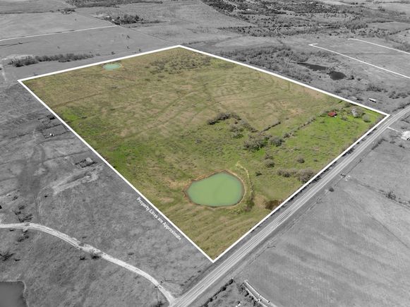
A tract of land at least 60-65 acres to be determined by a new survey provided by Buyer. The property is fenced grassland pasture that is fenced and cross fenced. 2 stock tanks in front and back pasture. There is an old farmstead at the corner where a mobile home that is not livable as well as a small wood garage. An old wood and tin barn. An old storage trailer and a very old camper that is not titled to owner. The small front pasture had been used for horses previously. Land is currently leased for grazing until May 2025. Partial minerals are available. Paved road frontage on 2 sides.
![]()
Last checked:
As a licensed real estate brokerage, Estately has access to the same database professional Realtors use: the Multiple Listing Service (or MLS). That means we can display all the properties listed by other member brokerages of the local Association of Realtors—unless the seller has requested that the listing not be published or marketed online.
The MLS is widely considered to be the most authoritative, up-to-date, accurate, and complete source of real estate for-sale in the USA.
Estately updates this data as quickly as possible and shares as much information with our users as allowed by local rules. Estately can also email you updates when new homes come on the market that match your search, change price, or go under contract.
![]() Checking…
•
Last updated Mar 30, 2025
•
Checking…
•
Last updated Mar 30, 2025
•
MLS# 20886316 —
Location
-
Directions:From Mt. Calm at HWY 31 & 339, Take FM 339 South towards Prairie Hill. Follow FM 339 South at least 3 miles to the Corner on LCR 106 & FM 339. The entry to the property is at the corner. SOP
-
Latitude:31.70912400
-
Longitude:-96.84517300
The Property
-
Property Type:Land
-
Property Subtype:Unimproved Land
-
Parcel Number:R1598
-
Lot Features:Acreage, Agricultural, Corner Lot, Level, Many Trees, Mesquite, Pasture, Tank/ Pond
-
Lot Size:50 to =< 100 Acres
-
Lot Size SqFt:2613600.0000
-
Lot Size Acres:60.0000
-
Lot Size Area:60.0000
-
Lot Size Units:Acres
-
Lot Size Source:Owner
-
Easements:Utilities
-
Restrictions:No Known Restriction(s)
-
Current Use:Agricultural, Cattle, Grazing, Hunting/Fishing, Pasture, Recreational
-
Possible Use:Agricultural, Cattle, Equine, Grazing, Horses, Hunting/Fishing, Ranch, Recreational
-
Exclusions:partial minerals, cattle or anything belonging to tenant that might be on the land at any ven time.
-
Zoning Description:un-zoned
-
Topography:level to very gently rolling grassland
-
Fencing:Barbed Wire, Fenced, Gate
-
Crops:Common Bermuda, Native, Non Irrigated, Other
-
Horse Permitted:Yes
-
Acres Pasture:60.00
-
Other Structures:Barn(s), Garage(s)
-
# of Barns:1
-
# of Tanks And Ponds:2
-
Road Frontage Type:County Road, FM Road
-
Road Surface Type:Asphalt
-
Will Subdivide:No
-
Land Lease:Yes
Listing Agent
- Contact info:
- No listing contact info available
Taxes
-
Tax Legal Description:A277 H & TC RR CO, ACRES @ 60 acres+
The Listing
-
Virtual Tour URL Unbranded:https://www.propertypanorama.com/instaview/ntreis/20886316
Utilities
-
Utilities:Asphalt, Co-op Water, Electricity Available, Outside City Limits, Phone Available
Schools
-
School District:Mount Calm ISD
-
Elementary School:Mtcalm
-
Elementary School Name:Mtcalm
-
Middle School Name:Mtcalm
-
High School Name:Mtcalm
The Community
-
Subdivision Name:Ab 277
-
Association Type:None
-
Development Status:Other
Walk Score®
Provided by WalkScore® Inc.
Walk Score is the most well-known measure of walkability for any address. It is based on the distance to a variety of nearby services and pedestrian friendliness. Walk Scores range from 0 (Car-Dependent) to 100 (Walker’s Paradise).
Bike Score®
Provided by WalkScore® Inc.
Bike Score evaluates a location's bikeability. It is calculated by measuring bike infrastructure, hills, destinations and road connectivity, and the number of bike commuters. Bike Scores range from 0 (Somewhat Bikeable) to 100 (Biker’s Paradise).