


668 Durham Road
NEWTOWN, PA 18940
- – beds
- – baths
- – sqft
- ~2 acre lot
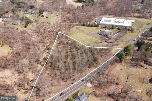
Wooded 2.1367 Acre Lot in Wrightstown Township and Desirable Council Rock School District! Map, Soil testing for Septic System & CR-2 zoning information Attached. See the Following Information Attached at the top of the Multiple Listing: Tax Map showing subdivided Lot. Zoned CR-2 Country Residential/Medium Density Districts, Information . Soil Investigation & Sewage System Permit Report. After you look at the attached Documents if you have Zoning Question's Call Wrightstown Township, Zoning Officer: Gary Smith, Monday, Wednesday & Friday : 8:00-4:30
![]()
Last checked:
As a licensed real estate brokerage, Estately has access to the same database professional Realtors use: the Multiple Listing Service (or MLS). That means we can display all the properties listed by other member brokerages of the local Association of Realtors—unless the seller has requested that the listing not be published or marketed online.
The MLS is widely considered to be the most authoritative, up-to-date, accurate, and complete source of real estate for-sale in the USA.
Estately updates this data as quickly as possible and shares as much information with our users as allowed by local rules. Estately can also email you updates when new homes come on the market that match your search, change price, or go under contract.
![]() Checking…
•
Last updated Mar 27, 2025
•
Checking…
•
Last updated Mar 27, 2025
•
MLS# PABU2090418 —
The Building
-
Historic:No
Financial & Terms
-
Sale Type:Standard
-
Acceptable Financing:Cash
-
Possession:Immediate
-
Lease Considered:No
Location
-
Directions:Located on Route 413 - Durham Road, between 2nd Street Pike (232) and Brownsburg Rd., From Second Street Pike(232) head towards Newtown, Lot is on the left just before Indian Walk Veterinary Center. Do Not Go To The Property Without an Appointment.
-
Cross Street:Brownsburg Rd.
-
Latitude:40.27400589
-
Longitude:-74.98758698
The Property
-
Property Type:Land
-
Property Subtype:Land
-
Current Use:Land/Lot Only
-
Lot Size Units:Square Feet
-
Lot Size Acres:2.14
-
Lot Size Source:Estimated
-
Lot Size Dimensions:500 x 440
-
Lot Dimensions Source:Estimated
-
Lot Features:Road Frontage, Trees/Wooded, Not In Development, Irregular
-
Lot SqFt:93,218 Sqft
-
Additional Parcels:No
-
Zoning:CR2
-
Road Frontage Length:500
-
Road Surface Type:Paved
-
View:Trees/Woods
-
Waterview:No
-
Waterfront:No
-
Water Oriented:No
-
Water Access:No
-
Navigable Water:No
-
Tidal Water:No
-
Farm Land Preservation:No
-
Ground Rent Exists:No
-
Riparian Rights:No
Listing Agent
- Contact info:
- Agent phone:
- (215) 272-2614
- Office phone:
- (215) 794-3227
Taxes
-
Tax ID Number:53-015-072-002
-
Tax Year:2025
-
Total Taxes Payment Frequency:Annually
Utilities
-
Sewer/Septic:Site Evaluation on File
-
Water Source:None
Schools
-
School District Name:Council Rock
-
School District Source:Listing Agent
The Community
-
Association Recreation Fee:No
-
HOA:No
-
Condo/Coop Association:No
Extra Units
-
Vacation Rental:No
Walk Score®
Provided by WalkScore® Inc.
Walk Score is the most well-known measure of walkability for any address. It is based on the distance to a variety of nearby services and pedestrian friendliness. Walk Scores range from 0 (Car-Dependent) to 100 (Walker’s Paradise).
Bike Score®
Provided by WalkScore® Inc.
Bike Score evaluates a location's bikeability. It is calculated by measuring bike infrastructure, hills, destinations and road connectivity, and the number of bike commuters. Bike Scores range from 0 (Somewhat Bikeable) to 100 (Biker’s Paradise).
Soundscore™
Provided by HowLoud
Soundscore is an overall score that accounts for traffic, airport activity, and local sources. A Soundscore rating is a number between 50 (very loud) and 100 (very quiet).
Sale history
| Date | Event | Source | Price | % Change |
|---|---|---|---|---|
|
3/27/25
Mar 27, 2025
|
Listed / Active | BRIGHT | $485,000 |