
63 Ac Frank Wood Road
Sherman, TX 75090
- – beds
- – baths
- – sqft
- ~63 acre lot
- – on site
More homes
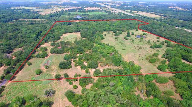
Lightly traveled county road... Land is crossed by Mustang Creek... The north side of the 63 plus or minus acres touches US Hwy 82... the west side of property has flood plain along the creek.. Ideal location for a high fence and a deer preserve... water line and electric in the area....this is the west part of a 99 acre tract that is available for sale also...land s mixture of sand and black dirt.. all sorts of trees..even some huge post oak trees... old home site is included on the 63 acres.. picturesque setting, with high ground... several areas to add ponds... Long road frontage... secluded setting... less than 10 minutes to the intersection of Us Hwy 82 and SH 289..See MLS#14647487 for 99 ac listing.
![]()
Last checked:
As a licensed real estate brokerage, Estately has access to the same database professional Realtors use: the Multiple Listing Service (or MLS). That means we can display all the properties listed by other member brokerages of the local Association of Realtors—unless the seller has requested that the listing not be published or marketed online.
The MLS is widely considered to be the most authoritative, up-to-date, accurate, and complete source of real estate for-sale in the USA.
Estately updates this data as quickly as possible and shares as much information with our users as allowed by local rules. Estately can also email you updates when new homes come on the market that match your search, change price, or go under contract.
![]() Checking…
•
Last updated Jan 28, 2025
•
Checking…
•
Last updated Jan 28, 2025
•
MLS# 14645662 —
Location
-
Directions:West from Sherman on US Hwy 82, pass SH 289 a few miles, south on Spalding Road, then left or west on Frank woods Road, land on north side of street in about one mile..
-
Latitude:33.66722600
-
Longitude:-96.82655300
The Property
-
Property Type:Land
-
Property Subtype:Ranch
-
Property Attached:No
-
Parcel Number:119474
-
Lot Features:Acreage, Bottom, Many Trees, Pasture, Rolling Slope
-
Lot Size:50 to =< 100 Acres
-
Lot Size SqFt:2744280.0000
-
Lot Size Acres:63.0000
-
Lot Size Area:63.0000
-
Lot Size Units:Acres
-
Subdivided:Yes
-
Easements:Other
-
Restrictions:Building, Deed
-
Current Use:Agricultural
-
Possible Use:Single Family
-
Exclusions:Seller to reserve all oil, gas and other minerals...
-
Zoning Description:Not Zoned
-
Fencing:Barbed Wire
-
Soil Type:Black, Sandy Loam
-
Horse Permitted:Yes
-
# of Tanks And Ponds:1
-
Waterfront Features:Creek
-
Road Assessment:No
-
Road Frontage Type:County Road
-
Road Surface Type:Asphalt
-
Will Subdivide:No
Listing Agent
- Contact info:
- No listing contact info available
The Listing
Utilities
-
Utilities:Co-op Water, Electricity Available, Sewer Not Available
Schools
-
School District:S and S Cons ISD
-
Elementary School:S And S
-
Elementary School Name:S And S
-
Middle Or Junior School:S And S
-
Middle School Name:S And S
-
High School:S And S
-
High School Name:S And S
The Community
-
Subdivision Name:W B Johnson A#656
-
Association Type:None
-
Development Status:Unzoned
Parking
-
Garage:No
Walk Score®
Provided by WalkScore® Inc.
Walk Score is the most well-known measure of walkability for any address. It is based on the distance to a variety of nearby services and pedestrian friendliness. Walk Scores range from 0 (Car-Dependent) to 100 (Walker’s Paradise).
Bike Score®
Provided by WalkScore® Inc.
Bike Score evaluates a location's bikeability. It is calculated by measuring bike infrastructure, hills, destinations and road connectivity, and the number of bike commuters. Bike Scores range from 0 (Somewhat Bikeable) to 100 (Biker’s Paradise).
Sale history
| Date | Event | Source | Price | % Change |
|---|---|---|---|---|
|
12/6/21
Dec 6, 2021
|
Sold | NTREIS |