


5522 Jason Street
Houston, TX 77096
- 3 beds
- 2 baths
- 1,590 sqft
- $1 per sqft
- 1962 build
- – on site
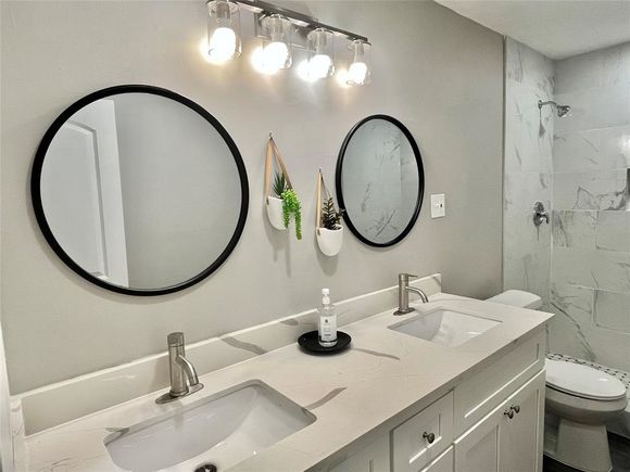
Cozy one story home, with 3 bedroom and 2 full bath, it totally renovated , new paint interior/exterior, everything is new in both bathrooms, new vinyl floor throughout. the house is in a very quite and safe neighborhood, it's zone to Bellaire High School, only five minutes walking distance to a community park and Herod Elementary School; 10 minutes walking to a grocery store and a bus station. Convenient location close to the Med Center, Houston Zoo, Galleria and easy access to High way 610, SW freeway, welcome to see it today.
![]()
Last checked:
As a licensed real estate brokerage, Estately has access to the same database professional Realtors use: the Multiple Listing Service (or MLS). That means we can display all the properties listed by other member brokerages of the local Association of Realtors—unless the seller has requested that the listing not be published or marketed online.
The MLS is widely considered to be the most authoritative, up-to-date, accurate, and complete source of real estate for-sale in the USA.
Estately updates this data as quickly as possible and shares as much information with our users as allowed by local rules. Estately can also email you updates when new homes come on the market that match your search, change price, or go under contract.
![]() Checking…
•
Last updated Mar 24, 2025
•
Checking…
•
Last updated Mar 24, 2025
•
MLS# 48544302 —
The Building
-
Year Built:1962
-
Year Built Source:Appraisal District
-
New Construction:No
-
Style:Traditional
-
Stories:1
Interior
-
Room Count:6
Financial & Terms
-
Rental Terms:Long Term, Six Months
-
Price SqFt List:$1.57
-
Price Acre List:15201.47
Location
-
Directions:Renwick and Beechnut
-
Latitude:29.683927
-
Longitude:-95.485588
The Property
-
Property Type:Rental
-
Property Subtype:Single Family Detached
-
Section Number:5
-
Parcel Number:092-289-000-0015
-
Acres:0.1638
-
Acres Description:0 up to 1/4 Acres
-
Lot Description:Subdivision Lot
-
Lot Size:7,137 Sqft
-
Lot Size Source:Appraisal District
-
Lot Price SqFt List:0.35
-
Total SqFt:1,590 Sqft
-
SqFt Source:Appraisal District
-
Area:20
-
Private Pool:No
-
Pool Area:No
Listing Agent
- Contact info:
- Agent phone:
- (832) 275-2046
- Office phone:
- (281) 566-2562
Beds
-
Total Bedrooms:3
Baths
-
Total Baths:2.00
-
Full Baths:2
The Listing
-
Status:Active
-
Disclosures:Owner/Agent
Heating & Cooling
-
Heat System:Central Gas
-
Cool System:Central Electric
Utilities
-
Water/Sewer:Public Sewer, Public Water
Schools
-
Elementary:HEROD ELEMENTARY SCHOOL
-
Middle School:FONDREN MIDDLE SCHOOL
-
High School:BELLAIRE HIGH SCHOOL
-
School District:27 - Houston
The Community
-
Subdivision:Maplewood
-
Active Community 55:No
-
Pets:Case By Case Basis
-
Restrictions:No Restrictions
-
Management Company:No
-
Other Fees:No
-
Master Planned Community:No
Parking
-
Garage Description:Attached Garage
-
# of Garage Cap:2
Walk Score®
Provided by WalkScore® Inc.
Walk Score is the most well-known measure of walkability for any address. It is based on the distance to a variety of nearby services and pedestrian friendliness. Walk Scores range from 0 (Car-Dependent) to 100 (Walker’s Paradise).
Bike Score®
Provided by WalkScore® Inc.
Bike Score evaluates a location's bikeability. It is calculated by measuring bike infrastructure, hills, destinations and road connectivity, and the number of bike commuters. Bike Scores range from 0 (Somewhat Bikeable) to 100 (Biker’s Paradise).
Transit Score®
Provided by WalkScore® Inc.
Transit Score measures a location's access to public transit. It is based on nearby transit routes frequency, type of route (bus, rail, etc.), and distance to the nearest stop on the route. Transit Scores range from 0 (Minimal Transit) to 100 (Rider’s Paradise).
Soundscore™
Provided by HowLoud
Soundscore is an overall score that accounts for traffic, airport activity, and local sources. A Soundscore rating is a number between 50 (very loud) and 100 (very quiet).
Air Pollution Index
Provided by ClearlyEnergy
The air pollution index is calculated by county or urban area using the past three years data. The index ranks the county or urban area on a scale of 0 (best) - 100 (worst) across the United Sates.