
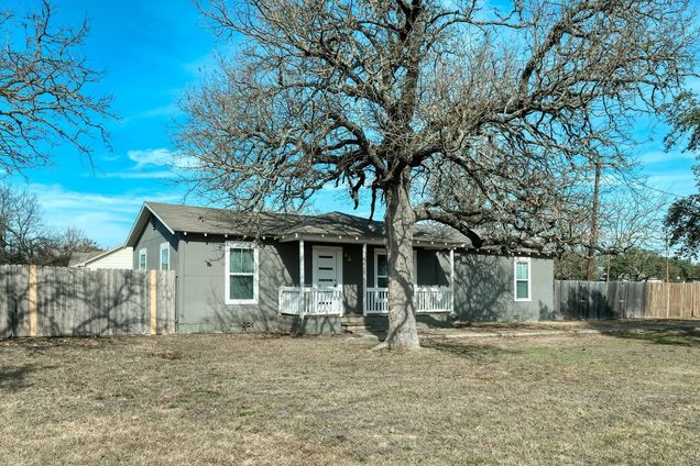


520 W Fm 243
Bertram, TX 78605
- 3 beds
- 2 baths
- 1,155 sqft
- $1 per sqft
- 1940 build
- – on site
Nice 3 bed 2 bath one story, no carpet throughout, granite counter tops in kitchen and bath with large open lot. All RPM Reliable Property Management, Inc. residents are enrolled in the Resident Benefits Package (RBP) for $50.00/month which includes liability insurance, credit building to help boost the resident’s credit score with timely rent payments, HVAC air filter delivery (for applicable properties), our best-in-class resident rewards program, and much more! More details upon application.
![]()
Last checked:
As a licensed real estate brokerage, Estately has access to the same database professional Realtors use: the Multiple Listing Service (or MLS). That means we can display all the properties listed by other member brokerages of the local Association of Realtors—unless the seller has requested that the listing not be published or marketed online.
The MLS is widely considered to be the most authoritative, up-to-date, accurate, and complete source of real estate for-sale in the USA.
Estately updates this data as quickly as possible and shares as much information with our users as allowed by local rules. Estately can also email you updates when new homes come on the market that match your search, change price, or go under contract.
![]() Checking…
•
Last updated Mar 14, 2025
•
Checking…
•
Last updated Mar 14, 2025
•
MLS# 1439515 —
The Building
-
Year Built:1940
-
New Construction:false
-
Roof:Metal
-
Foundation:Pillar/Post/Pier
-
Exterior Features:None
-
Accessibility Features:None
-
Patio And Porch Features:None
-
Window Features:None
-
Levels:One
-
Direction Faces:NW
Interior
-
Interior Features:Granite Counters
-
Living:1
-
Dining:1
-
Flooring:Carpet
-
Fireplace:None
-
Laundry Location:Laundry Room
Room Dimensions
-
Living Area:1155
-
Living Area Source:Public Records
Financial & Terms
-
Lease Term:12 Months
-
Lease Terms:12
-
Security Deposit:$1,595
-
Availability Date:2025-03-15
Location
-
Latitude:30.741143
-
Longitude:-98.063468
-
Directions:Hwy 29 west from Liberty Hill Turn west on 243 houns on right about 1 mile
The Property
-
Property Type:Residential Lease
-
Subtype:Single Family Residence
-
Parcel Number:03925030000005000
-
Property Condition:Resale
-
Lot Features:Level
-
Lot Size Acres:0.41
-
Lot Size Area:0 Sqft
-
Lot Size SqFt:17,859 Sqft
-
SqFt Total:1,155 Sqft
-
Lot Dimensions:.41
-
View:Hill Country
-
Waterfront:false
-
Waterfront Features:None
-
Horse:false
-
Fencing:Chain Link
-
FEMA Flood Plain:No
Listing Agent
- Contact info:
- Agent phone:
- (512) 618-9228
- Office phone:
- (512) 732-8388
Beds
-
Bedrooms Total:3
-
Main Level Bedrooms:3
Baths
-
Total Baths:2
-
Total Baths:2
-
Full Baths:2
The Listing
-
Occupant Type:Vacant
Heating & Cooling
-
Heating:Central
-
Cooling:Central Air
Utilities
-
Utilities:Electricity Available
-
Sewer:Public Sewer
-
Water Source:Public
-
Electric On Property:true
Appliances
-
Appliances:Dishwasher
Schools
-
Elementary School:Bertram
-
Elementary School District:Burnet CISD
-
Middle School:Burnet (Burnet ISD)
-
Middle School District:Burnet CISD
-
High School:Burnet
-
High School District:Burnet CISD
The Community
-
Subdivision Name:Countryside Oaks
-
Community Features:None
-
Pool Private:false
-
Pool Features:None
-
Spa Features:None
-
Pets Allowed:Cats OK
Parking
-
Parking Features:Assigned
-
Garage:false
-
Attached Garage:false
Walk Score®
Provided by WalkScore® Inc.
Walk Score is the most well-known measure of walkability for any address. It is based on the distance to a variety of nearby services and pedestrian friendliness. Walk Scores range from 0 (Car-Dependent) to 100 (Walker’s Paradise).
Bike Score®
Provided by WalkScore® Inc.
Bike Score evaluates a location's bikeability. It is calculated by measuring bike infrastructure, hills, destinations and road connectivity, and the number of bike commuters. Bike Scores range from 0 (Somewhat Bikeable) to 100 (Biker’s Paradise).
Air Pollution Index
Provided by ClearlyEnergy
The air pollution index is calculated by county or urban area using the past three years data. The index ranks the county or urban area on a scale of 0 (best) - 100 (worst) across the United Sates.