


31203 E Atherton Sibley Road
Sibley, MO 64088
- – beds
- – baths
- – sqft
- ~28 acre lot
- – on site
More homes
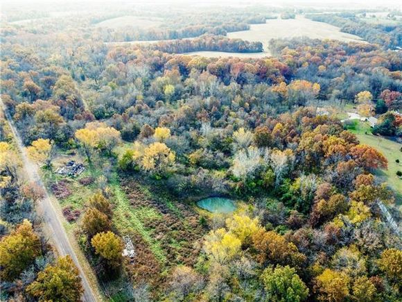
Tired of the hustle bustle in the city? Looking for a place to get away that is your own land? With almost 28 acres this partially fenced treed property at the end of Atherton Sibley Road offers the chance to hunt, see the stars, and have quiet evenings. If you want to build a home, the utilities are already available from a previous home on site. After closing, this property could be subdivided if buyer so chooses. Because it is in unincorporated Jackson County there are many options for this land. It's time to bring your imagination and the plans for your dream home!
![]()
Last checked:
As a licensed real estate brokerage, Estately has access to the same database professional Realtors use: the Multiple Listing Service (or MLS). That means we can display all the properties listed by other member brokerages of the local Association of Realtors—unless the seller has requested that the listing not be published or marketed online.
The MLS is widely considered to be the most authoritative, up-to-date, accurate, and complete source of real estate for-sale in the USA.
Estately updates this data as quickly as possible and shares as much information with our users as allowed by local rules. Estately can also email you updates when new homes come on the market that match your search, change price, or go under contract.
![]() Checking…
•
Last updated Jul 18, 2024
•
Checking…
•
Last updated Jul 18, 2024
•
MLS# 2409491 —
The Building
-
Development Status:Raw Land
Financial & Terms
-
Listing Terms:Cash, Conventional
-
Possession:Close Of Escrow
Location
-
Directions:291 Hwy N to 24 Hwy. Go East on 24 Hwy. Turn left onto N Elsea Smith Rd Turn right onto E Blue Mills Rd Turn left onto N Galvin Rd Turn right onto E Atherton Sibley Rd. Property on the Right.
The Property
-
Property Type:Land
-
Property Subtype:Land
-
Parcel Number:05-900-02-04-00-0-00-000
-
Lot Features:Acreage, Treed
-
Lot Size SqFt:1209225.6
-
Lot Size Area:27.76
-
Lot Size Units:Acres
-
Zoning:Rural
-
Current Use:Agriculture
-
Possible Use:Agricultural, Residential, Rural
-
Road Responsibility:Public Maintenance
-
Road Surface Type:Paved
-
Road Frontage Type:County Road
-
Topography:Level,Rolling
-
Vegetation:Partially Wooded
-
Fencing:Partial
-
Crops:None
-
Restrictions:Unknown
-
In Flood Plain:Yes
-
Agriculture Type:Pasture
-
Improvement Features:No Improvements
Listing Agent
- Contact info:
- Agent phone:
- (816) 820-4342
- Office phone:
- (816) 525-7000
Taxes
-
Tax Total Amount:997
Utilities
-
Sewer:Unknown
-
Water Source:Rural - Verify
Schools
-
High School:Fort Osage
-
High School District:Fort Osage
The Community
-
Subdivision Name:Other
-
Association:false
-
Association Fee Frequency:None
Walk Score®
Provided by WalkScore® Inc.
Walk Score is the most well-known measure of walkability for any address. It is based on the distance to a variety of nearby services and pedestrian friendliness. Walk Scores range from 0 (Car-Dependent) to 100 (Walker’s Paradise).
Bike Score®
Provided by WalkScore® Inc.
Bike Score evaluates a location's bikeability. It is calculated by measuring bike infrastructure, hills, destinations and road connectivity, and the number of bike commuters. Bike Scores range from 0 (Somewhat Bikeable) to 100 (Biker’s Paradise).
Max Internet Speed
Provided by BroadbandNow®
View a full reportThis is the maximum advertised internet speed available for this home. Under 10 Mbps is in the slower range, and anything above 30 Mbps is considered fast. For heavier internet users, some plans allow for more than 100 Mbps.
Sale history
| Date | Event | Source | Price | % Change |
|---|---|---|---|---|
|
1/18/24
Jan 18, 2024
|
Sold | HMLS | $400,000 | |
|
12/20/23
Dec 20, 2023
|
Pending | HMLS | $400,000 | |
|
10/21/22
Oct 21, 2022
|
Listed / Active | HMLS | $400,000 |