
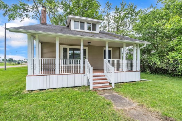


203 W Main Street
Springport, MI 49284
- 3 beds
- 2 baths
- 1,480 sqft
- 10,890 sqft lot
- $113 per sqft
- 1934 build
- – on site
More homes
HIGHEST AND BEST DUE NOON TODAY ! What a fantastic home in Springport! Walking distance to school and downtown. Just Move in! all the work is done! Lots of remodeling done! Fireplace in living room, Beautiful new kitchen with appliances, new flooring throughout, new Bathrooms, new mechanics! Kitchen countertops installed on 23rd. Don't miss it!
![]()
Last checked:
As a licensed real estate brokerage, Estately has access to the same database professional Realtors use: the Multiple Listing Service (or MLS). That means we can display all the properties listed by other member brokerages of the local Association of Realtors—unless the seller has requested that the listing not be published or marketed online.
The MLS is widely considered to be the most authoritative, up-to-date, accurate, and complete source of real estate for-sale in the USA.
Estately updates this data as quickly as possible and shares as much information with our users as allowed by local rules. Estately can also email you updates when new homes come on the market that match your search, change price, or go under contract.
![]() Checking…
•
Last updated Mar 22, 2025
•
Checking…
•
Last updated Mar 22, 2025
•
MLS# 22023069 —
The Building
-
Year Built:1934
-
New Construction:false
-
Construction Materials:Vinyl Siding
-
Architectural Style:Traditional
-
Foundation Details:None
-
Building Features:None
-
Accessibility Features:No
-
Direction Faces:None
-
Stories:2
-
Basement:No
-
Basement:Partial
-
Basement:Yes
-
Common Walls:None
-
Building Area Total:1480.0
-
Exterior Material -Vinyl Siding:true
Interior
-
Rooms Total:7
-
Fireplace:false
Room Dimensions
-
Living Area:1480.0
-
Main Level SqFt:1040.0
-
Upper Level SqFt:440.0
-
Basement SqFt:920.0
Location
-
Directions:M99 to downtown Springport. Left on Main st.
-
Cross Street:Eaton Rapids Rd
-
Latitude:42.378048
-
Longitude:-84.701053
The Property
-
Parcel Number:017-01-19-227-004-02
-
Property Type:Residential
-
Property Subtype:Single Family Residence
-
Property Attached:No
-
Lot Size SqFt:10890.0
-
Lot Size Acres:0.25
-
Lot Size Area:0.25
-
Lot Size Units:Acres
-
Topography:None
-
Waterfront:false
-
View:None
-
View:No
-
Inclusions:None
-
Zoning:None
-
Current Use:None
-
Possible Use:None
-
Frontage Type:None
-
Waterfront:No
-
Road Frontage:66.0
Listing Agent
- Contact info:
- Agent phone:
- (517) 395-8253
Taxes
-
Tax Year:2021
-
Tax Year:2021.0
-
Tax Legal Description:LOT 14 LANDON'S SUBDIVISION VILLAGE OF SPRINGPORT
-
Tax Annual Amount:1363.55
-
Tax Assessed Value:37362
-
Taxable Value:37362.0
-
Annual Property Taxes:1363.55
Beds
-
Bedrooms Total:3
-
Main Bedrooms:1
-
Main Level Bedrooms:1
Baths
-
Total Baths:2
-
Total Baths:2.0
-
Partial Baths:None
-
Full Baths:1
-
Full Baths:2
-
Full Baths:1
-
Three Quarter Baths:None
-
Quarter Baths:None
The Listing
-
Terms Available -VA Loan:true
Heating & Cooling
-
Cooling:No
-
Heating:true
-
Heating:Forced Air
-
Heat Type -Forced Air:true
-
Heat Source -Natural Gas:true
Utilities
-
Sewer:Public
-
Sewer -Publictrue
-
Water Source:Public
-
Water Public:true
Schools
-
Elementary School District:None
-
Middle Or Junior School District:None
-
High School District:Springport
The Community
-
Senior Community:No
-
Pool Private:No
-
Association:No
Parking
-
Garage:false
-
Attached Garage:No
-
Carport Spaces:None
-
Parking Total:None
Walk Score®
Provided by WalkScore® Inc.
Walk Score is the most well-known measure of walkability for any address. It is based on the distance to a variety of nearby services and pedestrian friendliness. Walk Scores range from 0 (Car-Dependent) to 100 (Walker’s Paradise).
Bike Score®
Provided by WalkScore® Inc.
Bike Score evaluates a location's bikeability. It is calculated by measuring bike infrastructure, hills, destinations and road connectivity, and the number of bike commuters. Bike Scores range from 0 (Somewhat Bikeable) to 100 (Biker’s Paradise).
Air Pollution Index
Provided by ClearlyEnergy
The air pollution index is calculated by county or urban area using the past three years data. The index ranks the county or urban area on a scale of 0 (best) - 100 (worst) across the United Sates.