
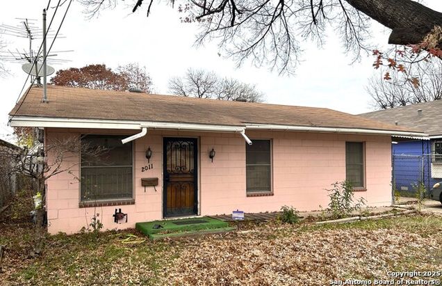


2011 LEAL ST
San Antonio, TX 78207
- 3 beds
- 2 baths
- 1,271 sqft
- 8,102 sqft lot
- $118 per sqft
- 1961 build
- – on site
More homes
This house is located in Central City, San Antonio, TX 78207. 2011 LEAL ST is a 1,271 square foot house with 3 beds and 2 baths that has been on Estately for 101 days. This house is in the attendance area of Lanier High School, Rhodes Middle School, and Ogden Elementary School.
![]()
Last checked:
As a licensed real estate brokerage, Estately has access to the same database professional Realtors use: the Multiple Listing Service (or MLS). That means we can display all the properties listed by other member brokerages of the local Association of Realtors—unless the seller has requested that the listing not be published or marketed online.
The MLS is widely considered to be the most authoritative, up-to-date, accurate, and complete source of real estate for-sale in the USA.
Estately updates this data as quickly as possible and shares as much information with our users as allowed by local rules. Estately can also email you updates when new homes come on the market that match your search, change price, or go under contract.
![]() Checking…
•
Last updated Apr 18, 2025
•
Checking…
•
Last updated Apr 18, 2025
•
MLS# 1832897 —
The Building
-
Year Built:1961
-
Approx Age:64
-
Construction:Pre-Owned
-
Builder Name:UNK
-
Type:Single Family Detached
-
Style:One Story
-
Exterior:Other
-
Roof:Wood Shingle/Shake
-
Foundation:Slab
-
# of Stories:1
-
Inclusions:Ceiling Fans, Washer Connection, Dryer Connection, Gas Water Heater
-
Total SqFt:1271
-
SqFt Source:Appsl Dist
Interior
-
Interior:Two Living Area
-
Window Coverings:None Remain
-
Floors:Ceramic Tile
-
Fireplace:Not Applicable
Room Dimensions
-
Kitchen Length:14
-
Kitchen Width:9
-
Family Room Length:14
-
Family Room Width:22
-
Master Bedroom Length:12
-
Master Bedroom Width:10
-
Bedroom 2 Length:10
-
Bedroom 2 Width:11
-
Bedroom 3 Length:12
-
Bedroom 3 Width:8
-
Master Bath Length:10
-
Master Bath Width:16
Financial & Terms
-
Potential Short Sale:No
-
Possession:Closing/Funding
Location
-
Directions:Ruiz, R on 19th Street, L on Leal
The Property
-
Area:0700
-
Legal Desc-Lot:3
-
Lot Size:0.186
-
Pool:No
-
Pool/Spa:No Pool
-
Price Per SqFt:$118.01
Listing Agent
- Contact info:
- Agent phone:
- (562) 619-8717
Taxes
-
Tax Property ID:021960030030
-
Tax Year:2024
-
Total Taxes:$1,877.02
-
Taxed by Multiple Counties:No
Beds
-
Total Bedrooms:3
Baths
-
Total Baths:2
-
Full Baths:2
-
Master Bath:Shower Only
-
Full and Half Baths:2
Heating & Cooling
-
Heating:Other Heating
-
Heating Fuel:Natural Gas
-
Air Conditioning:3+ Window/Wall
Utilities
-
Sewer:City
Schools
-
Elementary School:Ogden
-
Middle School:Irving
-
High School:Fox Tech
-
School District:San Antonio I.S.D.
The Community
-
Subdivision:26TH/ZARZAMORA
-
26TH/ZARZAMORASubdivision:
-
Senior Community:No
-
Neighborhood Amenities:None
-
HOA:None
Parking
-
Parking:Side Entry Parking
Walk Score®
Provided by WalkScore® Inc.
Walk Score is the most well-known measure of walkability for any address. It is based on the distance to a variety of nearby services and pedestrian friendliness. Walk Scores range from 0 (Car-Dependent) to 100 (Walker’s Paradise).
Bike Score®
Provided by WalkScore® Inc.
Bike Score evaluates a location's bikeability. It is calculated by measuring bike infrastructure, hills, destinations and road connectivity, and the number of bike commuters. Bike Scores range from 0 (Somewhat Bikeable) to 100 (Biker’s Paradise).
Transit Score®
Provided by WalkScore® Inc.
Transit Score measures a location's access to public transit. It is based on nearby transit routes frequency, type of route (bus, rail, etc.), and distance to the nearest stop on the route. Transit Scores range from 0 (Minimal Transit) to 100 (Rider’s Paradise).
Soundscore™
Provided by HowLoud
Soundscore is an overall score that accounts for traffic, airport activity, and local sources. A Soundscore rating is a number between 50 (very loud) and 100 (very quiet).
Air Pollution Index
Provided by ClearlyEnergy
The air pollution index is calculated by county or urban area using the past three years data. The index ranks the county or urban area on a scale of 0 (best) - 100 (worst) across the United Sates.
Sale history
| Date | Event | Source | Price | % Change |
|---|---|---|---|---|
|
4/6/25
Apr 6, 2025
|
Sold | SABOR | $150,000 | |
|
4/1/25
Apr 1, 2025
|
Pending | SABOR | $150,000 | |
|
1/7/25
Jan 7, 2025
|
Listed / Active | SABOR | $150,000 |