


11920 Upper Manatee River Road
BRADENTON, FL 34212
- – beds
- – baths
- – sqft
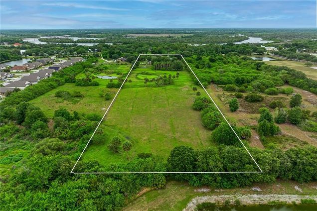
- ~8 acre lot
- – on site
IMPROVED LAND!!!!Rare opportunity to own 8 acres in the rapidly growing area of Manatee County! Perfect piece of land for growing families to build their dream home, or developers to envision the lot! UTILITY HOOKUPS! Currently zoned PDR; future land use UF-3. Developers, this is a prime location for a new community or apartment complex! Manatee river is right across the street making it a great view for a tall building! Not too many trees on the property- not much excavation needed! Small pond. Just 30 minutes from Sarasota County which is ranked #2 of best school districts in Florida and only 35 minutes from Anna Maria Island! Small Single-Family home and small barn included. The house on the property is 2bed 1bath, 888sqft.
![]()
Last checked:
As a licensed real estate brokerage, Estately has access to the same database professional Realtors use: the Multiple Listing Service (or MLS). That means we can display all the properties listed by other member brokerages of the local Association of Realtors—unless the seller has requested that the listing not be published or marketed online.
The MLS is widely considered to be the most authoritative, up-to-date, accurate, and complete source of real estate for-sale in the USA.
Estately updates this data as quickly as possible and shares as much information with our users as allowed by local rules. Estately can also email you updates when new homes come on the market that match your search, change price, or go under contract.
![]() Checking…
•
Last updated Apr 9, 2025
•
Checking…
•
Last updated Apr 9, 2025
•
MLS# A4644382 —
The Building
-
Building Area Units:Square Feet
Room Dimensions
-
Living Area Units:Square Feet
Location
-
Directions:Appointment only. There are cattle on the property. A short Due Diligence period is Required. Cash Offers Only. Please send all offers to the following email address: JulianG@germinal-group.com
-
Latitude:27.511828
-
Longitude:-82.422326
-
Coordinates:-82.422326, 27.511828
The Property
-
Parcel Number:547100206
-
Property Type:Land
-
Lot Size Acres:8
-
Lot Size Area:8
-
Lot Size SqFt:348480
-
Lot Size Dimensions:264' x 1320'
-
Lot Size Units:Acres
-
Total Acres:5 to less than 10
-
Zoning:PDR
-
Current Use:Residential
-
Direction Faces:North
-
View:false
-
Water Source:Public
-
Road Responsibility:Public Maintained Road
-
Road Surface Type:Paved
-
Road Frontage Type:State Road
-
Flood Zone Code:AE, X
-
Additional Parcels:false
-
Price Per Acre:287500
Listing Agent
- Contact info:
- Agent phone:
- (941) 556-0500
- Office phone:
- (941) 556-0500
Taxes
-
Tax Year:2024
-
Tax Legal Description:A TRACT OF LAND LYING IN SEC 20, & BEING MORE PARTICULARLY DESC AS FOL: COM AT THE NW COR OF THE NE1/4 OF SD SEC 20, TH S 00 DEG 13 MIN 15 SEC W, ALG THE W LN OF SD NE1/4 OF SEC 20, A DIST OF 40 FT TO THE INT WITH THE S R/W LN OF UPPER MANATEE RIVER RD; TH S 89 DEG 51 MIN 43 SEC E, ALG SD S R/W LN, A DIST OF 858 FT FOR A POB; TH CONT S 89 DEG 51 MIN 43 SEC E, ALG THE SD S R/W LN, A DIST OF 264 FT; TH S 00 DEG 13 MIN 15 SEC W, PAR TO & 1122 FT ELY OF THE W LN OF SD NW1/4 OF SEC 20, A DIST OF 1320 FT; TH N 89 DEG 51 MIN 43 SEC W, PAR & 1360 FT SLY OF THE N LN OF SD NE1/4 OF SEC 20, A DIST OF 264 FT; TH N 00 DEG 13 MIN 15 SEC E, 1320 FT TO THE POB (1442/6972) PI#5471.0020/6
-
Tax Annual Amount:1450
The Listing
-
Virtual Tour URL Unbranded:https://www.propertypanorama.com/instaview/stellar/A4644382
-
Special Listing Conditions:None
Utilities
-
Utilities:Electricity Available
-
Sewer:Septic Tank
Schools
-
High School:Lakewood Ranch High
The Community
-
Waterview:false
-
Water Access:false
-
Waterfront:false
-
Association:false
-
Ownership:Fee Simple
Extra Units
-
Other Structures:Barn(s)
Walk Score®
Provided by WalkScore® Inc.
Walk Score is the most well-known measure of walkability for any address. It is based on the distance to a variety of nearby services and pedestrian friendliness. Walk Scores range from 0 (Car-Dependent) to 100 (Walker’s Paradise).
Bike Score®
Provided by WalkScore® Inc.
Bike Score evaluates a location's bikeability. It is calculated by measuring bike infrastructure, hills, destinations and road connectivity, and the number of bike commuters. Bike Scores range from 0 (Somewhat Bikeable) to 100 (Biker’s Paradise).
Soundscore™
Provided by HowLoud
Soundscore is an overall score that accounts for traffic, airport activity, and local sources. A Soundscore rating is a number between 50 (very loud) and 100 (very quiet).
Sale history
| Date | Event | Source | Price | % Change |
|---|---|---|---|---|
|
3/12/25
Mar 12, 2025
|
Listed / Active | STELLAR_MLS | $2,300,000 | |
|
4/9/24
Apr 9, 2024
|
Price Changed | STELLAR_MLS | ||
|
10/15/23
Oct 15, 2023
|
Price Changed | STELLAR_MLS |