


1150 60 N Dahlia Street N
Denver, CO 80220
- – beds
- – baths
- – sqft
- 12,500 sqft lot
- – on site
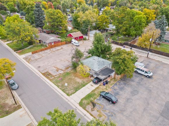
Amazing opportunity to build two new luxury homes across the street from Lindsley Park and in a location that is surrounded by thriving residential neighborhoods. The highest and best use for this rare 12,500 SF lot is to be subdivided into two 6,250 SF lots for two luxury new builds. Zoning is U-SU-C within the City and County of Denver. U-SU-C is a single unit district allowing urban houses with a minimum zone lot area of 5,500 square feet. Blocks typically have a consistent pattern of 50-foot-wide lots. Other large lots in the neighborhood are typically 6,250 SF and new home sales since 2021 have sold for as high as $1,640,000 to $2,849,000. Lindsley Park is a gem for the neighborhood and hosts four tennis courts, a basketball court, walking path, playground, horseshoe pit, baseball diamond, and a picnic area. Other notable developments in the area are the Rose Medical Center Complex and the 41-acre former University of Colorado Health Sciences Center mixed-use redevelop site that calls for approximately 900 residential units, up to 300,000-square-feet for retail, restaurant and a 140-room hotel, up to 200,000-square-feet of office space, 2,600 parking spaces and four acres of park and greenspace for the development and surrounding neighborhoods. The current home on the site is being sold as-is and has a long-term tenant leasing on a m-t-m basis.
![]()
Last checked:
As a licensed real estate brokerage, Estately has access to the same database professional Realtors use: the Multiple Listing Service (or MLS). That means we can display all the properties listed by other member brokerages of the local Association of Realtors—unless the seller has requested that the listing not be published or marketed online.
The MLS is widely considered to be the most authoritative, up-to-date, accurate, and complete source of real estate for-sale in the USA.
Estately updates this data as quickly as possible and shares as much information with our users as allowed by local rules. Estately can also email you updates when new homes come on the market that match your search, change price, or go under contract.
![]() Checking…
•
Last updated Feb 8, 2025
•
Checking…
•
Last updated Feb 8, 2025
•
MLS# 8068116 —
Location
-
Latitude:39.73403834
-
Longitude:-104.93120627
The Property
-
Property Type:Land
-
Property Subtype:Improved Land
-
Parcel Number:6061-25-004
-
Current Use:Residential, Vacant
-
Possible Use:Residential
-
Zoning:U-SU-C
-
Lot Features:Level
-
Lot Size Area:12500
-
Lot Size Acres:0.29
-
Lot Size SqFt:12500
-
Lot Size Dimensions:100 x 125
-
Lot Size Units:Square Feet
-
Exclusions:Tenant Personal Property
-
Fencing:Partial
-
Road Responsibility:Public Maintained Road
-
Road Frontage Type:Public
-
Road Surface Type:Alley Paved, Paved
Listing Agent
- Contact info:
- Agent phone:
- (720) 937-4403
- Office phone:
- (720) 937-4403
Taxes
-
Tax Year:2024
-
Tax Annual Amount:2531
-
Tax Legal Description:L 8 TO 12 INC BLK 5 KEATINGS COLFAX AVE SUB
Utilities
-
Utilities:Cable Available, Electricity Available, Electricity Connected, Natural Gas Available, Natural Gas Connected, Phone Available, Sewer Connected
-
Electric:220 Volts
-
Sewer:Public Sewer
-
Water Included:Yes
-
Water Source:Public
Schools
-
Elementary School District:Denver 1
-
Middle Or Junior School District:Denver 1
-
High School District:Denver 1
The Community
-
Subdivision Name:Mayfair
-
Association:false
Parking
-
Parking Features:Asphalt, Parking Lot
-
Attached Garage:false
Walk Score®
Provided by WalkScore® Inc.
Walk Score is the most well-known measure of walkability for any address. It is based on the distance to a variety of nearby services and pedestrian friendliness. Walk Scores range from 0 (Car-Dependent) to 100 (Walker’s Paradise).
Bike Score®
Provided by WalkScore® Inc.
Bike Score evaluates a location's bikeability. It is calculated by measuring bike infrastructure, hills, destinations and road connectivity, and the number of bike commuters. Bike Scores range from 0 (Somewhat Bikeable) to 100 (Biker’s Paradise).
Transit Score®
Provided by WalkScore® Inc.
Transit Score measures a location's access to public transit. It is based on nearby transit routes frequency, type of route (bus, rail, etc.), and distance to the nearest stop on the route. Transit Scores range from 0 (Minimal Transit) to 100 (Rider’s Paradise).
Soundscore™
Provided by HowLoud
Soundscore is an overall score that accounts for traffic, airport activity, and local sources. A Soundscore rating is a number between 50 (very loud) and 100 (very quiet).