


11200 Sweet Pea Road Unit Parcel E
Gilmer, TX 75644
- – beds
- – baths
- – sqft
- ~12 acre lot
- – on site
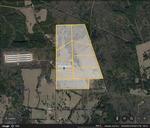
A rare find for east Texas property. This listing is for Parcel E, depicted in the attached photo, and is approximately 11.6 acres along the western side of the subject property. The area is comprised of beautiful rolling land, some wooded area, and pasture acreage that is currently serving as the ranch home of a livestock operation raising bison and cattle. The overall property has premium fencing of 6 ft high, 6 strand wire surrounding the external boundary, with some similar internal fencing separating pastures. It encompasses the northern part of a 232 acre plat, from which 158 acres will be divided at closing. Parcels A & B have road access at a corner to the parcel, whereas Parcels C through I, have some road frontage. The parcels can be purchased as displayed, or a larger parcel can be created by either combining designated parcels, or by negotiating custom boundaries contained within the overall acreage. The resulting parcel will be re-platted for closing. (The depicted parcel boundaries are approximated from Google Earth.)
![]()
Last checked:
As a licensed real estate brokerage, Estately has access to the same database professional Realtors use: the Multiple Listing Service (or MLS). That means we can display all the properties listed by other member brokerages of the local Association of Realtors—unless the seller has requested that the listing not be published or marketed online.
The MLS is widely considered to be the most authoritative, up-to-date, accurate, and complete source of real estate for-sale in the USA.
Estately updates this data as quickly as possible and shares as much information with our users as allowed by local rules. Estately can also email you updates when new homes come on the market that match your search, change price, or go under contract.
![]() Checking…
•
Last updated Apr 15, 2025
•
Checking…
•
Last updated Apr 15, 2025
•
MLS# 20852453 —
Location
-
Directions:From the Valero station at Midway TX (10 miles north of Gilmer TX on US 271 north), proceed 2.5 miles east on FM 593, turn north (left) on FM 1975 for 2.5 miles, turn north on Sweet Pea Road. Owner will meet buyers-agents for appointments at the ranch house on the right. APPOINTMENTS ARE REQUIRED.
-
Latitude:32.89708000
-
Longitude:-94.90031200
The Property
-
Property Type:Land
-
Property Subtype:Ranch
-
Parcel Number:000000046871
-
Lot Features:Acreage
-
Lot Size:10 to < 50 Acres
-
Lot Size SqFt:505296.0000
-
Lot Size Acres:11.6000
-
Lot Size Area:11.6000
-
Lot Size Units:Acres
-
Lot Size Source:Owner
-
Subdivided:Yes
-
Easements:Electric
-
Restrictions:Easement(s), No Known Restriction(s)
-
Current Use:Agricultural, Cattle, Crops and Livestock, Feed Lot, Grazing, Pasture, Ranch
-
Possible Use:Agricultural, Cattle, Dairy, Feed Lot, Grazing, Horses, Hunting/Fishing, Investment, Livestock, Pasture, Ranch
-
Zoning Description:Agriculture
-
Fencing:Barbed Wire, High Fence, Pipe
-
Crops:Coastal Bermuda, Common Bermuda, Hardwood Timber, Improved Pasture, Native, Non Irrigated, Softwood Timber
-
Soil Type:Clay, Sandy Loam
-
Vegetation:Cleared, Grassed, Partially Wooded
-
Horse Permitted:Yes
-
Unit Number:Parcel E
-
Surface Rights:All, Easement
-
Road Frontage Type:County Road, FM Road
-
Road Surface Type:Asphalt
-
Will Subdivide:Yes
-
Land Lease:No
Listing Agent
- Contact info:
- No listing contact info available
Taxes
-
Tax Legal Description:ABS A204 HARRISON COUNTY SCHOOL LAND,TRACT 1
The Listing
-
Virtual Tour URL Unbranded:https://www.propertypanorama.com/instaview/ntreis/20852453
Utilities
-
Utilities:All Weather Road, Asphalt, Electricity Available, Outside City Limits, Overhead Utilities, Unincorporated
Schools
-
School District:Gilmer ISD
-
Elementary School:Gilmer
-
Elementary School Name:Gilmer
-
Jr High School Name:Gilmer
-
Intermediate School Name:Gilmer
-
High School Name:Gilmer
The Community
-
Subdivision Name:HARRISON COUNTY SC HOOL LAND,TRACT 1
-
Association Type:None
-
Development Status:Zoned
Walk Score®
Provided by WalkScore® Inc.
Walk Score is the most well-known measure of walkability for any address. It is based on the distance to a variety of nearby services and pedestrian friendliness. Walk Scores range from 0 (Car-Dependent) to 100 (Walker’s Paradise).
Bike Score®
Provided by WalkScore® Inc.
Bike Score evaluates a location's bikeability. It is calculated by measuring bike infrastructure, hills, destinations and road connectivity, and the number of bike commuters. Bike Scores range from 0 (Somewhat Bikeable) to 100 (Biker’s Paradise).
Max Internet Speed
Provided by BroadbandNow®
This is the maximum advertised internet speed available for this home. Under 10 Mbps is in the slower range, and anything above 30 Mbps is considered fast. For heavier internet users, some plans allow for more than 100 Mbps.