


0 Skiff Drive
Gun Barrel City, TX 75156
- – beds
- – baths
- – sqft
- ~1/2 acre lot
- – on site
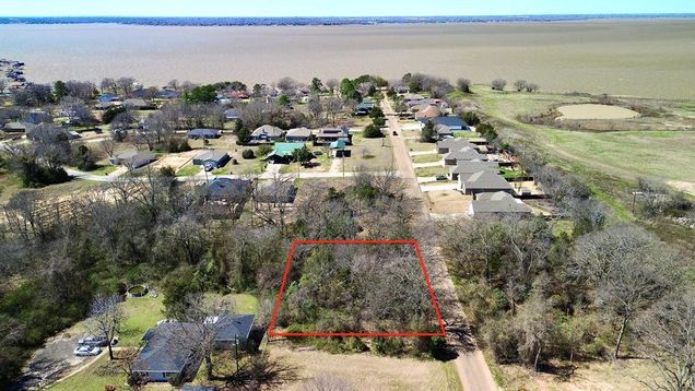
TWO SPACIOUS LOTS, IN THE HARBOR POINT COMMUNITY IN GUN BARREL CITY! NESTLED ON A PRIVATE ROAD, THESE LOTS OFFER BOTH SECLUSION AND CONVENIENCE, JUST MINUTES FROM CEDAR CREEK LAKE, SHOPPING, & DINING. WITH BEAUTIFUL SCATTERED TREES, YOU HAVE THE FREEDOM TO DESIGN YOUR IDEAL LANDSCAPE-KEEP THE SHADE YOU LOVE AND CLEAR SPACE FOR YOUR NEW BUILD. WHETHER YOU'RE LOOKING FOR A PEACEFUL RETREAT OR A WEEKEND GETAWAY, THIS PROPERTY IS FULL OF POSSIBILITIES!
![]()
Last checked:
As a licensed real estate brokerage, Estately has access to the same database professional Realtors use: the Multiple Listing Service (or MLS). That means we can display all the properties listed by other member brokerages of the local Association of Realtors—unless the seller has requested that the listing not be published or marketed online.
The MLS is widely considered to be the most authoritative, up-to-date, accurate, and complete source of real estate for-sale in the USA.
Estately updates this data as quickly as possible and shares as much information with our users as allowed by local rules. Estately can also email you updates when new homes come on the market that match your search, change price, or go under contract.
![]() Checking…
•
Last updated Mar 7, 2025
•
Checking…
•
Last updated Mar 7, 2025
•
MLS# 20863420 —
Location
-
Directions:HEAD WEST ON 334, TURN RIGHT ONTO HARBOR POINT RD, TURN LEFT ONTO FIRST MATE, TURN RIGHT ONTO STARBOARD DR, CONTINUE ONTO SKIFF DR. LOTS ON LEFT.
-
Latitude:32.35510300
-
Longitude:-96.15087400
The Property
-
Property Type:Land
-
Property Subtype:Unimproved Land
-
Parcel Number:29300011026053
-
# of Lots:2
-
Lot Features:Level, Many Trees, Other, Sloped, Subdivision
-
Lot Size:Less Than .5 Acre (not Zero)
-
Lot Size Dimensions:80.85'x110.55'
-
Lot Size SqFt:16805.4480
-
Lot Size Acres:0.3858
-
Lot Size Area:0.3858
-
Lot Size Units:Acres
-
Easements:Other
-
Restrictions:Building, Deed
-
Possible Use:Residential
-
Zoning Description:RESIDENTIAL
-
Topography:LEVEL, SLOPED
-
Vegetation:Heavily Wooded, Partially Wooded
-
Frontage Feet:151
-
Road Frontage Type:City Street
-
Will Subdivide:No
Listing Agent
- Contact info:
- No listing contact info available
Taxes
-
Tax Lot:26
-
Tax Block:11
-
Tax Legal Description:LT 26, 27 AB 1017 L STOVAR SUR, HARBOR POIN
The Listing
-
Virtual Tour URL Unbranded:https://www.propertypanorama.com/instaview/ntreis/20863420
Utilities
-
Utilities:MUD Sewer, MUD Water
Schools
-
School District:Mabank ISD
-
Elementary School:Mabank
-
Elementary School Name:Mabank
-
Jr High School Name:Mabank
-
Intermediate School Name:Mabank
-
High School Name:Mabank
The Community
-
Subdivision Name:Harbor Point Sec 1
-
Community Features:Boat Ramp, Lake, Other
-
Association Type:Voluntary
-
Association Fee:100
-
Association Fee Frequency:Annually
-
Development Status:Plat Approved, Streets Installed, Zoned, Other
Walk Score®
Provided by WalkScore® Inc.
Walk Score is the most well-known measure of walkability for any address. It is based on the distance to a variety of nearby services and pedestrian friendliness. Walk Scores range from 0 (Car-Dependent) to 100 (Walker’s Paradise).
Bike Score®
Provided by WalkScore® Inc.
Bike Score evaluates a location's bikeability. It is calculated by measuring bike infrastructure, hills, destinations and road connectivity, and the number of bike commuters. Bike Scores range from 0 (Somewhat Bikeable) to 100 (Biker’s Paradise).
Soundscore™
Provided by HowLoud
Soundscore is an overall score that accounts for traffic, airport activity, and local sources. A Soundscore rating is a number between 50 (very loud) and 100 (very quiet).