


0 Lane 4 North
Mosca, CO 81146
- – beds
- – baths
- – sqft
- ~40 acre lot
- – on site
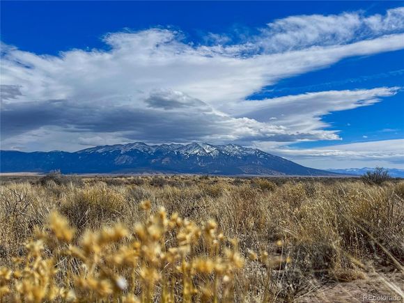
This 40-acre property offers stunning panoramic views, including Mount Blanca, and a direct sightline to the Great Sand Dunes. Accessed by a private road, it provides a sense of seclusion while still being just over 20 minutes from the Sand Dunes and Zapata Falls. Bordering a Water Conservation Property, the land benefits from occasional water overflow a few times a year, adding to its natural character. The area has a rich history, with many arrowheads found on the property, offering a glimpse into the past. The property has been previously surveyed, with corners clearly marked, making it easy to identify boundaries. With gorgeous clear night skies, this land is perfect for stargazing, camping, building a home, or even more possibilities. Expansive open space, incredible landscapes, and a connection to both nature and history make this a unique piece of land in the San Luis Valley.
![]()
Last checked:
As a licensed real estate brokerage, Estately has access to the same database professional Realtors use: the Multiple Listing Service (or MLS). That means we can display all the properties listed by other member brokerages of the local Association of Realtors—unless the seller has requested that the listing not be published or marketed online.
The MLS is widely considered to be the most authoritative, up-to-date, accurate, and complete source of real estate for-sale in the USA.
Estately updates this data as quickly as possible and shares as much information with our users as allowed by local rules. Estately can also email you updates when new homes come on the market that match your search, change price, or go under contract.
![]() Checking…
•
Last updated Mar 27, 2025
•
Checking…
•
Last updated Mar 27, 2025
•
MLS# 3916952 —
This property is listed in more than one place. See it here.
The Building
-
New Construction:false
Room Dimensions
-
Living Area Units:Square Feet
Financial & Terms
-
Listing Terms:Cash
Location
-
Directions:Gate is the following GPS Coordinates. 37.634440, -105.774017 Follow the easement road until you cross a tiny bridge, and then the road should go right. Follow it until you see the Pole/Corner marking of the property on your right.
-
Coordinates:-105.767662, 37.644333
-
Latitude:37.644333
-
Longitude:-105.767662
The Property
-
Property Type:Land
-
Property Subtype:Unimproved Land
-
Lot Features:Abuts Public Open Space
-
Lot Size Acres:40
-
Lot Size SqFt:1742400
-
Lot Size Area:1742400
-
Lot Size Units:Square Feet
-
Zoning:Rural Residential
-
View:Mountain(s)
-
Exclusions:None
-
Horse:false
-
Water Source:No Water/Sewer
-
Waterfront:false
-
Road Surface Type:Dirt
Listing Agent
- Contact info:
- No listing contact info available
Taxes
-
Tax Year:2023
-
Tax Annual Amount:502
The Listing
-
Special Listing Conditions:Private Owner
Utilities
-
Sewer:No Water/Sewer
Schools
-
High School District:Sangre De Cristo RE-22J
The Community
-
Subdivision Name:N/A
-
Association:false
-
Senior Community:false
Parking
-
Attached Garage:false
-
Garage Type:None
Walk Score®
Provided by WalkScore® Inc.
Walk Score is the most well-known measure of walkability for any address. It is based on the distance to a variety of nearby services and pedestrian friendliness. Walk Scores range from 0 (Car-Dependent) to 100 (Walker’s Paradise).
Bike Score®
Provided by WalkScore® Inc.
Bike Score evaluates a location's bikeability. It is calculated by measuring bike infrastructure, hills, destinations and road connectivity, and the number of bike commuters. Bike Scores range from 0 (Somewhat Bikeable) to 100 (Biker’s Paradise).
Sale history
| Date | Event | Source | Price | % Change |
|---|---|---|---|---|
|
2/10/25
Feb 10, 2025
|
Listed / Active | IRES | $50,000 |