
0 E Benson Airport Road
Benson, AZ 85602
- – beds
- – baths
- – sqft
- ~2 acre lot
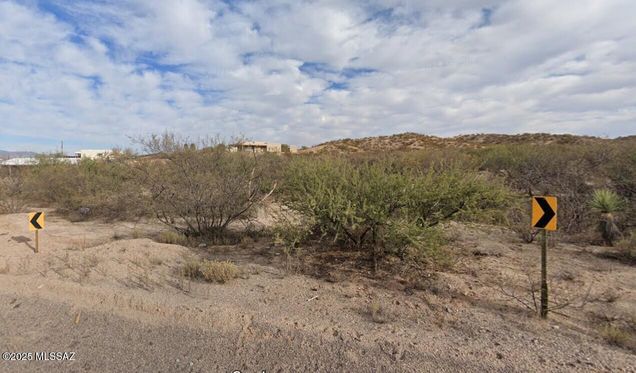
AFFORDABLE 1.5 ACRES WITH TREES AND UTILITIES ACCESS! The freedom of a rural lifestyle just outside of the Benson city limits. PAVED ROAD! State land abuts to the east! Flat & useful land with a gentle rise from the road. Horse property! Elevation is about 4000ft so get ready for cooler summers! Overhead electric poles along Benson Airport Rd. Shared well is 2 doors west. Benson and Interstate 10 are just a few minutes drive. Benson has Walmart, Safeway, hospital & many local stores and restaurants!
![]()
Last checked:
As a licensed real estate brokerage, Estately has access to the same database professional Realtors use: the Multiple Listing Service (or MLS). That means we can display all the properties listed by other member brokerages of the local Association of Realtors—unless the seller has requested that the listing not be published or marketed online.
The MLS is widely considered to be the most authoritative, up-to-date, accurate, and complete source of real estate for-sale in the USA.
Estately updates this data as quickly as possible and shares as much information with our users as allowed by local rules. Estately can also email you updates when new homes come on the market that match your search, change price, or go under contract.
![]() Checking…
•
Last updated Mar 2, 2025
•
Checking…
•
Last updated Mar 2, 2025
•
MLS# 22506113 —
The Building
-
Direction:E
Financial & Terms
-
Terms:Cash, Conventional
-
Short Sale:None
-
Fire Protection Included in Taxes:None
Location
-
Directions:I-10/Exit 306, 4th St East, Benson Airport Rd south, pass Goldenrod Ln, then, Benson Airport Rd curves due east, then, as it turns south again, you are now at the lot for sale which is on the north side of the curve. 1624 E Benson Airport Rd is the west neighbor.
-
Latitude:31.951906
-
Longitude:-110.260644
The Property
-
Legal Description:per assessor: E161.09' OF FLLNG DESC POR BEG AT NW COR SWSW S417.42' E1320' N417.42' W1320' TO BEG SEC 13-17-20 1.54AC
-
Municipality/Zoning:Cochise - R-36
-
Property Type:B
-
Property Subtype:Residential
-
Area:Benson/St. David
-
Lot Acres:1.54
-
Lot Size:161 x 425 approx.
-
Lot SqFt:67082
-
Lot Size Price/SqFt:$22,727.27
-
Lot Size Source:Assessor
-
Lot Features:North/South Exposure
-
Lot Features Adjacent:State
-
Lot Features Topography:Rolling
-
View:Mountain(s), Rural
-
Road Type:Paved
-
Road Maintenance:County
-
Fence:None
-
Horse Property:Yes - By Zoning
-
Municipal Flood Zone:TBD
-
Distance To Electric:100ft to be verified
-
Distance to Gas:use propane
-
Distance To Water:2 doors west
-
Distance To Sewer:septic required
-
Distance to Phone:unknown
Listing Agent
- Contact info:
- Agent phone:
- (520) 349-7322
- Office phone:
- (520) 918-4800
Taxes
-
Taxes:$209.50
-
Tax Year:2024
-
Tax Code:123-33-001D
The Listing
-
Environmental Disclosures:Seller Prop Disclosure, Unknown
-
Special Conditions:None
Utilities
-
Electric:Electric Company
-
Electric:Available
-
Sewer:Septic Required
-
Gas:None
-
Water:Shared Well, Well Agreement
-
Water:Available
Appliances
-
Range:20.00
Schools
-
Elementary School:Benson
-
Middle School:Benson
-
High School:Benson
-
School District:Benson
The Community
-
Subdivision:N/A
-
Subdivision Restrictions: Age Restrictions:No
-
Facilities:None
-
HOA Association & Fees:No
Walk Score®
Provided by WalkScore® Inc.
Walk Score is the most well-known measure of walkability for any address. It is based on the distance to a variety of nearby services and pedestrian friendliness. Walk Scores range from 0 (Car-Dependent) to 100 (Walker’s Paradise).
Bike Score®
Provided by WalkScore® Inc.
Bike Score evaluates a location's bikeability. It is calculated by measuring bike infrastructure, hills, destinations and road connectivity, and the number of bike commuters. Bike Scores range from 0 (Somewhat Bikeable) to 100 (Biker’s Paradise).
Sale history
| Date | Event | Source | Price | % Change |
|---|---|---|---|---|
|
3/1/25
Mar 1, 2025
|
Listed / Active | MLSSAZ | $35,000 |