


0 Bill Hart Road
Newnan, GA 30265
- – beds
- – baths
- ~10 acre lot
- – on site
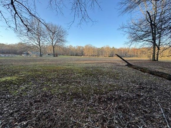
Welcome to this beautiful 10-acre wooded lot in the historic City of Homes, Newnan, Georgia, located in Coweta County near the charming community of Raymond. Just 3.5 miles from Newnan Hospital and the Interstate 85/Poplar Rd exit, this property offers the perfect blend of privacy and convenience. It's only 5 miles from Ashley Park and 6.5 miles from the heart of uptown Newnan. The land is mostly flat with gentle slopes, featuring stunning old oak trees, a small stream, and multiple potential building sites. This lot can easily be divided into two 5-acre tracts with minimal effort and offers the potential for higher density development due to its current zoning. The plat is included in the photos, and the lot is clearly marked on QPublic. Create your own mini-farm or family compound in this serene setting, while still enjoying the close proximity to all the amenities that Newnan, Senoia, and Peachtree City have to offer!
![]()
Last checked:
As a licensed real estate brokerage, Estately has access to the same database professional Realtors use: the Multiple Listing Service (or MLS). That means we can display all the properties listed by other member brokerages of the local Association of Realtors—unless the seller has requested that the listing not be published or marketed online.
The MLS is widely considered to be the most authoritative, up-to-date, accurate, and complete source of real estate for-sale in the USA.
Estately updates this data as quickly as possible and shares as much information with our users as allowed by local rules. Estately can also email you updates when new homes come on the market that match your search, change price, or go under contract.
![]() Checking…
•
Last updated Mar 28, 2025
•
Checking…
•
Last updated Mar 28, 2025
•
MLS# 7545380 —
The Building
-
Security Features:None
-
House SqFt:1250
Interior
-
Other Equipment:None
Location
-
Directions:This property is located between 330 Bill Hart Rd to the North and 363 Joe Cox Rd to the South. The property location borders unused railroad tracks.
-
Latitude:33.343011
-
Longitude:-84.702006
The Property
-
Parcel Number:112 1020 010
-
Property Type:Land
-
Property Type:Land
-
Property Subtype:Single Family Residence
-
Lot Features:Creek On Lot
-
Lot Size Acres:10.06
-
Lot Size Dimensions:x
-
Lot Size Source:Owner
-
Zoning:RC
-
Zoning Description:Undeveloped/Zoned Residential
-
Current Use:Cattle
-
Possible Use:Agricultural
-
View:Rural
-
Vegetation:Brush
-
Fencing:None
-
Horse Amenities:None
-
Other Structures:None
-
Waterfront Features:None
-
Water Body Name:None
-
Road Frontage Type:City Street
-
Road Surface Type:Asphalt
-
Property Attached:false
-
Habitable Residence:false
Listing Agent
- Contact info:
- Agent phone:
- (678) 458-2232
- Office phone:
- (866) 462-8823
Taxes
-
Tax Year:2024
-
Tax Annual Amount:1074
-
Tax Lot:20
The Listing
-
Home Warranty:false
-
Special Listing Conditions:None
-
Special Circumstances:None
Utilities
-
Utilities:Phone Available
Schools
-
Elementary School:Poplar Road
-
Middle Or Junior School:East Coweta
-
High School:East Coweta
The Community
-
Subdivision Name:None
-
Community Features:Stream Seasonal
-
Association:false
-
Pool Private:false
Listing Provided Courtesy of Heritage Oaks Realty, LLC
![]()
Listings identified with the FMLS IDX logo come from FMLS and are held by brokerage firms other than the owner of this website and the listing brokerage is identified in any listing details. Information is deemed reliable but is not guaranteed. If you believe any FMLS listing contains material that infringes your copyrighted work, please click here to review our DMCA policy and learn how to submit a takedown request. © 2025 First Multiple Listing Service, Inc.
Walk Score®
Provided by WalkScore® Inc.
Walk Score is the most well-known measure of walkability for any address. It is based on the distance to a variety of nearby services and pedestrian friendliness. Walk Scores range from 0 (Car-Dependent) to 100 (Walker’s Paradise).
Bike Score®
Provided by WalkScore® Inc.
Bike Score evaluates a location's bikeability. It is calculated by measuring bike infrastructure, hills, destinations and road connectivity, and the number of bike commuters. Bike Scores range from 0 (Somewhat Bikeable) to 100 (Biker’s Paradise).